Information about Nevado de Colima, Mexico
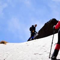
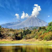 The Parque Nacional Volcán Nevado de Colima comprises two spell-binding volcanoes rising north of Colima. The Volcán de Colima (3860m), also known as Volcán de Fuego, is officially still active and smokes from time to time, though there seems little imminent danger. It is far less frequently climbed than its larger and more passive brother, the Nevado de Colima (4330m), which, with its pine- and oak-forested slopes, is popular with local mountaineers during the clear, dry winter months. Unless there’s a lot of snow in December and January crampons and an ice axe are essential and provided you are fit and can get transport high enough, it’s a relatively easy hike up to the summit. The most popular option is to ascend the Nevado de Colima from the cabin at La Joya (3500m); the usual route is via a steep climb to the radio antennae (“Las Antenas”), from where it’s another stiff but non-technical walk to the summit. Joining an organized tour is the hassle-free alternative and recommended for less experienced hikers.
 Independently, you’ll need to set three days aside for the climb, take a sleeping bag and waterproofs, pack enough food and water for the trip and walk from the village of El Fresnito. First, take a bus from Terminal Forañea in Colima to Ciudad Guzmán (about 1hr 30min) and from there catch a bus from stall #21 to El Fresnito, where there are very limited supplies. Ask for the road to La Joya take this and keep right until the route becomes obvious. This rough service road for the radio antennae leads up through cow pastures and goes right past the cabin at La Joya, about six to eight hours’ walking (35km). You pay the entry fee and can tank up from the supply of running water here, but don’t expect to stay in the hut, which is often locked, and even if open may be full, as it only sleeps six bring camping equipment. Plan on a day from La Joya to the summit and back, then another to get back to Colima, though a very fit walker starting before dawn could make the trip back to Colima, or at least Ciudad Guzmán, in a day. Note that hitching isn’t an option as the logging roads up here are rough, requiring high clearance or 4WD vehicles, and see very little traffic.
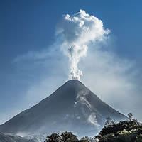
 Parque Nacional Nevado de Colima; This national park, straddling the Colima-Jalisco border, includes two dramatic volcanoes: the still-active Volcan de Fuego and the inactive Volcan Nevado de Colima. Ciudad Guzman is the closest city, but Colima is a more pleasant base. The adventure tour operators, run day trips from Colima to Volcan Nevado de Colima's peak, with English-speaking guides. Tours includes transportation, food/beverages and entry fees. But you must book in advance. It can be difficult to find a guide on the fly if you only have a few days. Volcan De Fuego Overlooking Colima, 30km north of the city is steaming Volain de Fuego (3820m) - Mexico's most active volcano. It has erupted dozens of times in the past four centuries, with a big eruption about every 70 years. A profound belch in 1913 marked the end of one cycle of activity, but another began in the 1960s. Current nunbling started in 1998 and has included pyroclastic flows and the growth of lava domes. In June 2005 a large explosion sent ash 4.8km into the sky, all the way to Colima. Current information about the volcano is posted on the website of the Universidad de Colima.
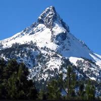 Volcan Nevado De Colima The higher, more northerly peak, Nevado de Colima (4240m) is accessible on foot for most of the year. Patches of pine forest cover Nevado's shoulders, while alpine desert takes over at the highest altitudes. Area wildlife includes deer, wild boar, coyotes and even a few mountain lions. The best months for climbing are the dry months of December through May. But temperatures from December to February often dip below 0°C and snow does regularly fall on the upper slopes - nevado means `snow covered.' Weather changes fast here and lightning strikes the peak in stormy weather, so make sure you keep an eye on the clouds. The park's winter hours are 7am to 6pm (no cars up after 2pm). The summer rainy season is from July to September, when park hours are longer. To access the volcano with your own car (rear-wheel drive cars can handle the road during the dry winter) you need to start early. Take highway 54D (the cuota, or toll road) north from Colima, get off at the Tuxpan exit and follow the 'Guadalajara libre' signs. Just before you reach Ciudad Guzman, turn left onto the El Grillo road. Drive 8.5km and you'll see the gravel road marked 'Nevado de Colima' on the left. Some 20 winding kilometers later you'll reach La Joya/Puerto Las Cruces (3500m), where you can sign in. The micro-ondas (radio antennae) are a strenuous 90-minute hike up from the end of the road. If you want to bag the peak, you'll need another 90 minutes and while the peak is easy to see, you shouldn't go alone. There are many trails up and back and it's very easy to get lost or led to areas with hazardous footing. Going with a guide or good maps and GPS is highly recommended. Bring extra water driving up this volcano on the relatively good dirt road means that you'll be ascending to a high altitude very quickly. If you feel lightheaded or dizzy, you may be suffering from mal de montania (altitude sickness). Descend as quickly as possible, as this condition can be potentially fatal. For more on this health problem.
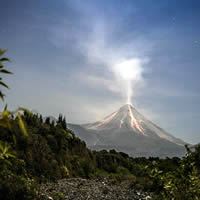 The Volcan Nevado de Colima climate shows signs of severe glacial erosion making it difficult to determine some aspects of its history. Today it is possible to find snow pyroclastic materials to more than 80 km away from the crater caused by an eruption of catastrophic magnitudes accompanied by avalanches and voluminous lahars believed was not before the Pleistocene. Unlike other large stratovolcano in central Mexico, which are associated with the subduction of the Cocos plate with the North American plate, the Colima Volcanic Complex shares both a unique feature that associates it with an irregular tectonic movement, fed by the transfer of the Tectonic Block Jalisco to the sub-plate Rivera. This movement moves the western sector of Jalisco to the west. It is located in an area marked by the formation of grabens and faults that run forming a horseshoe from Colima to Tepic through the central part of Jalisco. Snowy vegetation is temperate and cold pine-oak, fir and juniper. From the altitude of 4000 meters above sea level there is known as alpine tundra ecosystem where zacatonales and mosses are the main plants, as trees (pines, firs) stop growing at this point.
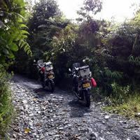 As for the wildlife that is present in the Snowy tailed deer inhabit the banking, peccary, puma, ocelot or ocelot, various snakes and other reptiles, and numerous species of birds such as the eagle, wild chickens, and a variety of insects. Both plant and animal, the park has many endemic, that is, the presence of species that inhabit a particular place only. The area where the volcano is located is protected by the Mexican government with the decree of Nevado de Colima National Park contemplating an area of 6,554 hectares. The natural area also protects the nearby Volcan de Fuego, which was then considered the most active volcano in Mexico, which still takes that position. It is common during the winter snow cover, which is frequently visited between November and March. To access the top of this volcano is necessary to move to the town of Ciudad Guzman in Jalisco state, hence the highway to La Mesa and El Fresnito which warns signaling the way to national park, once admitted to the protected area, the dirt road leading to antennas that are in the 4000 meters final point to where cars can reach. The National Park Nevado "The Colima" is a Mexican natural park is located within the boundaries of the states of Jalisco (83%) and Colima (17%). The park hosts the Colima Volcano and the Nevado de Colima. It covers a total area of 9,375 hectares and is administered by the Secretariat of Environment and Natural Resources of the State of Jalisco. The park has control booth, parking, cabins and a hostel.
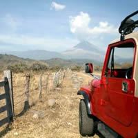 The natural area is located in the Transverse Volcanic Belt System. It has elevations ranging from 2,200 to 4,330 meters above sea level. Within the park are two of the most important summits of Mexico, the volcano Nevado de Colima, which are at a distance of 9 kilometers from each other. The soil consists mainly of volcanic ash. In the area of the park can be seen canyons, forests, streams, rivers and lagoons. The Nevado de Colima has 4.330 meters of altitude, is an ancient volcanic massif, its crater is 150 meters in diameter. The Colima Volcano of Fire: Volcano is an active stratovolcano type has 3,600 meters, the crater is 1.800 meters in diameter and has 250 meters depth. Its formation can be traced to early Pleistocene, the rocks are composed of basalt, horblenda, andesite and pumice. The volcano continuously emits gases and vapors, the June 6, 2005, the largest in 20 years eruption occurred. Inside the park ecotourism it is practiced include hiking, climbing, mountain biking and mountaineering. The park is visited by national and foreign tourists. Educational institutions visit the park with educational and recreational purposes, picnics, camps and study of wild fauna and flora are made. Typical campgrounds are: Antennas, Pico de Aguila, Las Viboras and El Leoncito; from where you can see great landscapes. The park has three types of climate: cold, tropical and temperate. Its average temperature during the months of January and February is between 5 and 7 ° C. During the summer (April-May) the average temperature is between 16 and 34 ° C. During the winter the average temperature is between -2 and -5 ° C.
MexicGo © 2023
